

You Are Hiking into Unfamiliar Terrain in Zion National Park: What Is the Best Way to Keep Your Bearings?
Preparation Before Hiking in Zion National Park
Before setting foot on Zion National Park’s stunning but challenging trails, proper preparation is essential. One of the first steps is to research Zion National Park hiking routes and trail conditions. Websites like the official National Park Service (NPS) site provide real-time updates on trail closures, flash flood alerts, and route difficulties. In addition, platforms like AllTrails and Gaia GPS offer hiker reviews, trail photos, and maps that can guide your planning.
Download offline hiking maps for Zion National Park before starting your adventure. Trails like The Narrows or Angels Landing can quickly lose cell reception, making offline maps on AllTrails or Gaia GPS invaluable. These apps allow you to track your position even when you’re disconnected from mobile networks, helping you stay on course.
Another crucial preparation tip is to inform someone about your hiking route in Zion. Share your itinerary with a family member or friend, including your start time, expected return time, and trail name. In the event of an emergency, this information can expedite rescue operations and ensure your safety.
Essential Tools to Stay Oriented While Hiking Zion National Park
When hiking into unfamiliar terrain in Zion National Park, carrying the right orientation tools is vital. A physical compass and a topographic map of Zion National Park trails are foundational tools every hiker should bring. These provide reliable navigation even if your electronic devices fail.
GPS hiking apps are also essential for navigating Zion routes. Applications like Gaia GPS and AllTrails Pro offer real-time GPS tracking. They show elevation profiles, trail forks, and distances, which are particularly useful in complex terrains like the Kolob Canyons or Observation Point trails.
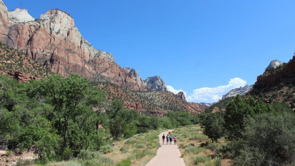
Understanding and following Zion trail markers and cairns (rock piles) can make the difference between staying on the path or getting lost. Trail markers are usually found at key intersections and difficult segments. Cairns, used in more remote areas, are unofficial but effective trail indicators. Make a mental note of these signs during your hike.
Natural Navigation Techniques in Zion National Park Terrain
In case your electronic tools fail, knowing natural navigation techniques in Zion National Park can help you find your way. One method involves using the sun’s position to navigate Zion’s canyons and ridges. In the Northern Hemisphere, the sun rises in the east and sets in the west, allowing you to maintain directional awareness throughout the day.
Another natural technique is identifying moss patterns on trees, especially in shaded Zion trails. Moss tends to grow more heavily on the north side of trees due to limited sunlight exposure. This can act as a general compass when in doubt.
Following river flow direction in Zion National Park can also serve as a navigation aid. Rivers like the Virgin River generally flow southward. If you’re lost and near a water source, following its downstream flow can lead to trailheads or park facilities.
Best Technology Tips to Stay Oriented in Zion National Park
Technology can significantly enhance your navigation experience in Zion. Using your phone compass correctly on Zion hiking trails starts with calibrating it before the hike. Most smartphones allow you to calibrate by moving your device in a figure-eight motion. Use the compass in conjunction with your offline maps to confirm directions.
Carrying satellite messengers like Garmin inReach or SPOT devices is a game changer for remote hikes in Zion. These devices allow you to send location data and emergency SOS signals even without cell service. They are especially valuable in secluded areas like the Subway or the East Rim Trail.
Keep external battery backups for navigating Zion terrain. A dead phone or GPS can leave you disoriented. Solar chargers or high-capacity power banks ensure that your devices stay functional for the duration of your hike.
What to Do If You Get Lost in Zion National Park
Even the most prepared hikers can get lost. Applying the STOP method — Stop, Think, Observe, Plan — is essential when you’re disoriented in Zion National Park. Immediately stop walking to prevent further straying from the trail. Think about your last known location. Observe your surroundings, using landmarks, sun position, or river flow to orient yourself. Plan your next move carefully.
Deciding whether to stay put or backtrack on Zion trails depends on your specific situation. If you recently left a marked trail, backtracking may lead you back. However, if you’re deep into unfamiliar terrain, staying put and signaling for help may be safer.
Avoid common panic responses when lost in Zion wilderness. Panicking leads to poor decisions and increased risk. Stay calm, assess your resources, and try to establish communication with emergency services using your satellite messenger or mobile device if possible.
Real-Life Navigation Scenarios in Zion National Park
There are several real-life examples of hikers getting lost in Zion National Park. One well-known incident involved a hiker losing their way in The Narrows due to a sudden flash flood. The hiker underestimated the speed of rising water and failed to identify escape routes. Fortunately, a GPS signal helped rescuers locate them.
Another scenario involved hikers at Angels Landing missing a turn and venturing onto an unmarked path. This led to hours of delay and increased exposure to cliff edges. These cases highlight the importance of following established trail markers in Zion’s unfamiliar terrain.
Common mistakes made by hikers in Zion include overreliance on technology, ignoring weather alerts, and hiking without proper maps. Each of these can quickly lead to dangerous situations.
Lessons learned from real Zion National Park incidents emphasize the need for thorough preparation, situational awareness, and the use of both traditional and modern navigation tools.
Local Safety Regulations for Hiking in Zion National Park
Understanding local safety regulations for hiking in Zion National Park enhances your safety and helps preserve the environment. Wildlife safety rules in Zion are crucial — maintain distance from animals like bighorn sheep, deer, and snakes. Feeding wildlife is prohibited and dangerous.
Know Zion National Park emergency contact numbers and ranger stations. The Zion Canyon Visitor Center and Kolob Canyons Visitor Center are key places to seek help. Always keep these numbers handy:
- Emergency: 911
- Zion Dispatch: (435) 772-3322
Check weather alerts and trail closures before entering Zion. Monsoon season can bring sudden flash floods, especially in slot canyons. The NPS website and trailhead bulletin boards provide up-to-date information. Ignoring these alerts has led to numerous rescues and fatalities.
By following these best practices and staying informed, your adventure in Zion National Park can be both exhilarating and safe. Always respect nature, use your tools wisely, and be prepared for the unexpected when hiking into unfamiliar terrain.
FAQ
How far is Zion National Park from Las Vegas?
Zion National Park is approximately 160 miles (260 km) from Las Vegas, Nevada. The drive takes around 2.5 to 3 hours via I-15 North and UT-9 East.
Las Vegas to Zion National Park?
To travel from Las Vegas to Zion National Park, rent a car and take Interstate 15 North to UT-9 East. It’s a scenic 2.5–3 hour drive. Shuttle or tour bus services are also available, especially during peak seasons.
How to get to Zion National Park?
The easiest way to get to Zion National Park is by car, entering through the South Entrance near Springdale, Utah. Visitors coming from afar can fly into Las Vegas (LAS) or Salt Lake City (SLC), then drive or take a shuttle to the park.
Where to fly into for Zion National Park?
The nearest major airports are:\n- Las Vegas McCarran International Airport (LAS) – 160 miles\n- Salt Lake City International Airport (SLC) – 300 miles\n- St. George Regional Airport (SGU) – 50 miles (with limited flights)\nFrom any of these, you can rent a car or book a shuttle to reach Zion.
Can you drive through Zion National Park?
Yes, you can drive through certain areas of Zion National Park. However, private vehicles are restricted on Zion Canyon Scenic Drive from March to late November. During this time, visitors must use the free park shuttle system. Other routes, like Kolob Canyons Road and Zion-Mount Carmel Highway, remain open to cars year-round.
Where to stay in Zion National Park?
Inside the park, you can stay at the historic Zion Lodge, located in Zion Canyon. For a more immersive experience, campgrounds like Watchman Campground and South Campground are available (seasonal and reservation-based).
Hotels near Zion National Park?
There are several highly-rated hotels near Zion’s South Entrance in Springdale, Utah, such as:\n- Cliffrose Springdale, Curio Collection by Hilton\n- Cable Mountain Lodge\n- La Quinta Inn & Suites by Wyndham Springdale\n- SpringHill Suites by Marriott\nThese options offer convenient access to the park shuttles and visitor center.